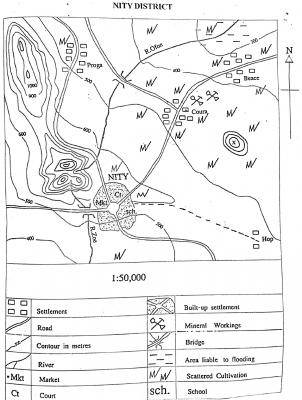
A. 800 m
B. 900 m
C. 1250 m
D. 1400 m
Correct Answer:
Option C = 1250 m

A. 800 m
B. 900 m
C. 1250 m
D. 1400 m
Correct Answer:
Option C = 1250 m
 Land Law and the Consequences of Unauthorized Land Transfers in Nigeria
Original price was: ₦1,000.00.₦300.00Current price is: ₦300.00.
Co-Ownership Structures and Land Acquisition Methods in Nigeria
Original price was: ₦1,000.00.₦300.00Current price is: ₦300.00.
Rights in Community Land and Fundamental Land Concepts in Nigeria
Original price was: ₦1,000.00.₦300.00Current price is: ₦300.00.
Customary Land Control and the Origins of Nigeria's Land Use Act
Original price was: ₦1,000.00.₦300.00Current price is: ₦300.00.
Land Ownership Principles and Transaction Laws in Nigeria
Original price was: ₦1,000.00.₦300.00Current price is: ₦300.00.
Land Law and the Consequences of Unauthorized Land Transfers in Nigeria
Original price was: ₦1,000.00.₦300.00Current price is: ₦300.00.
Co-Ownership Structures and Land Acquisition Methods in Nigeria
Original price was: ₦1,000.00.₦300.00Current price is: ₦300.00.
Rights in Community Land and Fundamental Land Concepts in Nigeria
Original price was: ₦1,000.00.₦300.00Current price is: ₦300.00.
Customary Land Control and the Origins of Nigeria's Land Use Act
Original price was: ₦1,000.00.₦300.00Current price is: ₦300.00.
Land Ownership Principles and Transaction Laws in Nigeria
Original price was: ₦1,000.00.₦300.00Current price is: ₦300.00.
Copyright warnings! Do not copy.

